NORDIC SURVEILLANCE SOLUTION
Connecting drones across environments in one powerful system
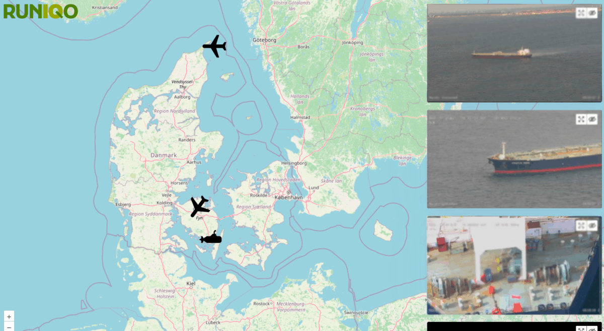
RUNIQO AND MULTI-DOMAIN SURVEILLANCE
Modern surveillance demands rapid response and reliable intelligence from land, sea, and air. Runiqo powers the Nordic Surveillance Solution by integrating multi-domain drone data into one cohesive system, enabling real-time situational awareness and secure decision-making.
Whether monitoring maritime zones, inspecting critical infrastructure, or conducting tactical operations, Nordic Surveillance Solution combines encrypted data streams, AI-enhanced detection, and seamless visualization. Runiqo’s platform transforms raw sensor input into actionable insight—securely, instantly, and globally.
RUNIQO AND THE ENVIRONMENT
Modern surveillance demands rapid response and reliable intelligence from land, sea, and air. Runiqo powers the Nordic Surveillance Solution by integrating multi-domain drone data into one cohesive system, enabling real-time situational awareness and secure decision-making.

Whether monitoring maritime zones, inspecting critical infrastructure, or conducting tactical operations, Nordic Surveillance Solution combines encrypted data streams, AI-enhanced detection, and seamless visualization. Runiqo’s platform transforms raw sensor input into actionable insight—securely, instantly, and globally.
COORDINATING SECURITY ACROSS DOMAINS

-
Multi-drone data fusion
With Nordic Surveillance Solution, Runiqo connects aerial, subsea, and land-based drones into a unified ecosystem, where live data streams are fused and visualized in real-time. This integration enables decision-makers to monitor complex operations across domains without switching between systems. The result is a seamless overview with high data fidelity—available instantly, anywhere.
-
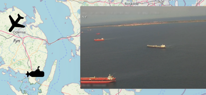
Long-range maritime surveillance
The Nordic Surveillance Solution supports long-range drone operations across expansive maritime zones like the Baltic Sea and the Strait of Gibraltar. Real-time video, radar, and AIS data are securely transmitted to command centers. For example, systems like those used by Nordic Unmanned demonstrate how high-endurance drones can enhance maritime domain awareness and support rapid operational response.
-
Land-based infrastructure monitoring
Short- and medium-range drones—such as the Astero ISR platform from Nordic Wing —are well suited for surveillance of land-based infrastructure, including power stations, railways, and critical transport corridors. Used in several defence and security contexts, including operations in Ukraine, platforms like these are easily integrated into the Nordic Surveillance Solution for efficient monitoring and rapid deployment.
-
Subsea inspection and awareness
The Nordic Surveillance Solution also integrates data from underwater ROVs, enabling inspection of harbours, vessels, and offshore platforms down to 100 meters. Solutions like those from Blue Atlas Robotics—already proven in naval contexts—provide a valuable underwater perspective that complements aerial and land-based surveillance, creating full-domain awareness.
SYSTEM OVERVIEW
- Nordic Surveillance Solution
- The RUNIQO System
- NSS at a glance
The Nordic Surveillance Solution connects three drone types in one system:
– Long-range aerial drones (150+ km, 9–11 hr)
– Medium-range drones (up to 50 km, 4+ hr)
– Subsea ROVs for underwater inspections
All platforms transmit live data to land- or vessel-based control stations, enabling real-time, cross-domain situational awareness.
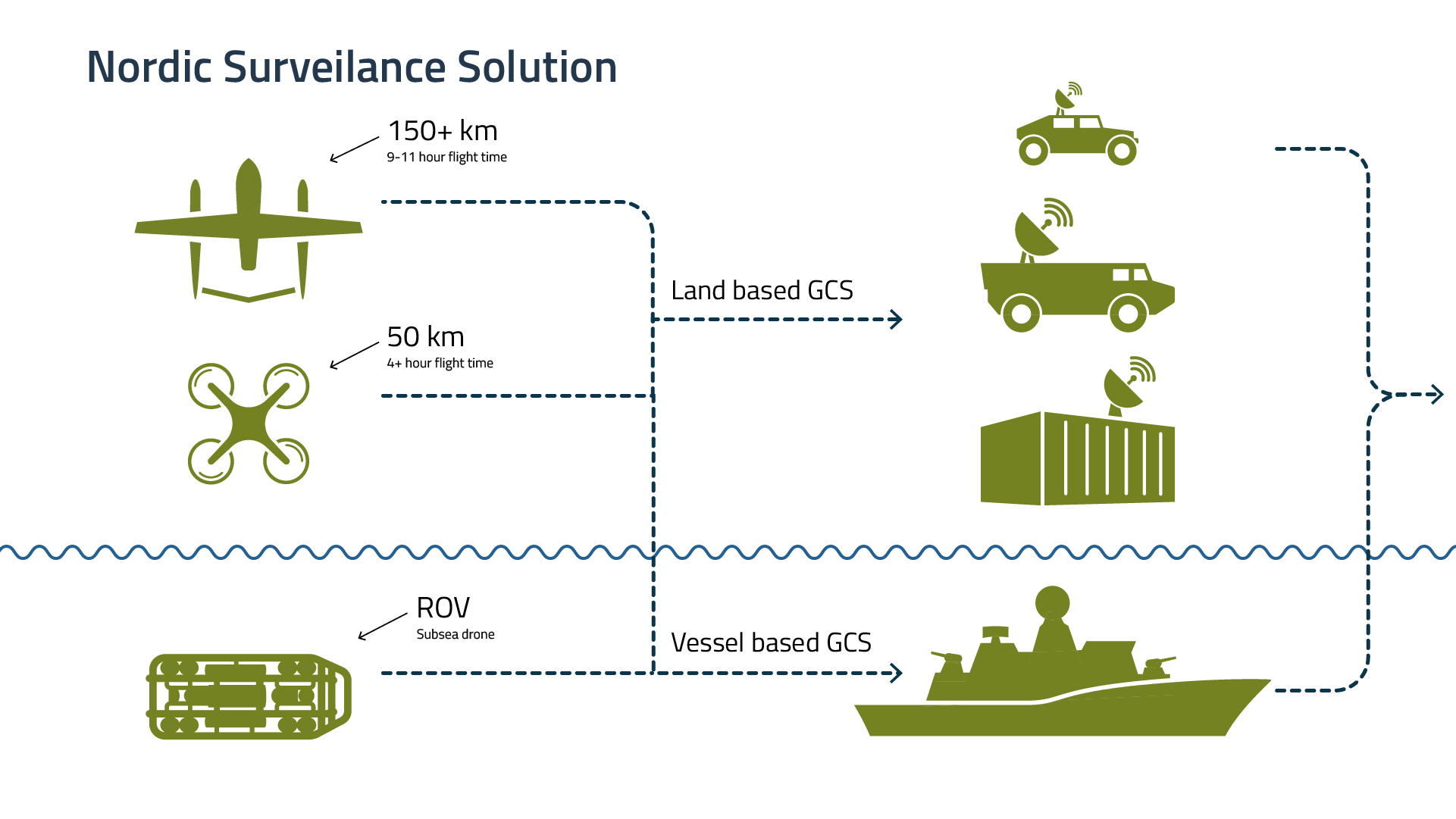
The Nordic Surveillance Solution connects aerial and subsea drones to both land- and vessel-based Ground Control Stations (GCS).
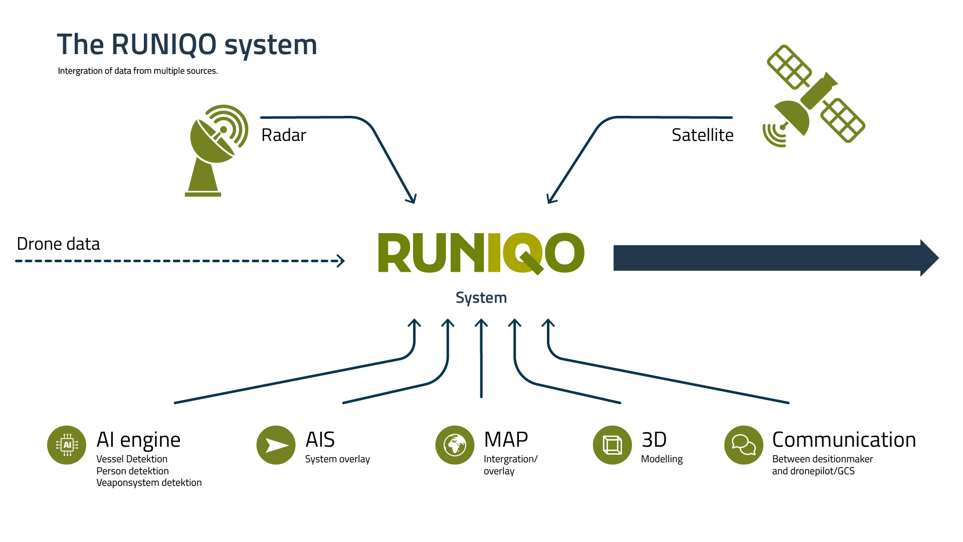 The Runiqo system fuses data from drones, radar, and satellites into a unified operational platform. Integrated tools such as AIS, mapping, 3D modelling, and an AI engine for vessel and threat detection enhance situational awareness. Secure communication links ensure real-time coordination between decision-makers and drone operators.
DATA SHEET
Security – NATO Standard
- Encrypted in SRT streams with STANAG 4609
Default: AES 256 encryption
FIPS 140-2 compliant
Supports alternative stream types, e.g. custom hardware encryption
Two-factor authentication required for login access
Flexible, Real-Time Awareness
- Real-time data with minimal latency
-
Independent operation across drone types and platforms
-
Geographically flexible – works across regions and mission types
-
Interoperable with external systems like radar, AIS, and satellite
-
Modular integration for scalable and mission-specific deployments
FIVE LEVELS OF DATA PROCESSING WITH RUNIQO
Level 1: Reception and Storage of Raw Data
Operators and analysts needing to collect high volumes of unprocessed data—such as drone video feeds, sensor outputs, and radar pings—will benefit from this foundational level of the Nordic Surveillance Solution. All incoming data is securely received and stored, ensuring nothing is lost and enabling replay or post-mission analysis when time allows.
Level 2: Integrated Data
At this level, data from multiple sources—such as satellite input, visual/thermal feeds, AIS, and GPS—is merged into a unified operational picture. This gives frontline operators and analysts a real-time, high-level overview of unfolding situations across land, sea, and air. Ideal for routine surveillance or multi-sensor missions that require quick interpretation but not full standardization.
Level 3: Consolidated Data
Standardized and structured output makes this level ideal for agencies and command centers that need to distribute actionable intelligence across teams or stakeholders. Whether tracking vessel movements, reporting airspace activity, or logging subsea inspections, this level ensures consistent, interoperable data for documentation, reporting, or collaboration.
Level 4: Light Viewer
For high-stakes operations requiring immediate action—such as identifying unauthorized vessels, monitoring restricted areas, or responding to critical events—this level offers low-latency access to real-time drone feeds and processed data. Decision-makers can monitor missions as they happen and issue rapid directives based on live intelligence.
Level 5: Full viewer with historical data
For long-term security planning, forensic review, or pattern analysis, this level provides access to both real-time and archived mission data. Users can replay past missions, compare event patterns, and build strategic insight over time—essential for intelligence-led operations, mission debriefs, or trend detection across large operational areas.
Runiqo’s five levels of data analysis in the Nordic Surveillance Solution are built to support a wide range of mission-critical and security-focused operations, including:
-
Drone operators and mission technicians
Collect and transmit real-time data from aerial, subsea, and land-based drones to provide accurate situational input for surveillance, inspections, and tactical missions.
-
Intelligence analysts and defence units
Monitor patterns in vessel activity, unauthorized movements, or infrastructure anomalies using integrated data from radar, AIS, infrared, and video sources.
-
Law enforcement and regulatory agencies
Rely on standardized and consolidated drone data to ensure compliance with maritime and border regulations, and to support investigation and enforcement efforts.
-
Strategic planners and command centers
Access historical data and mission replays to assess long-term patterns, evaluate risk, and support intelligence-led planning and cross-agency coordination.
-
Operations managers and field commanders
Use live feeds and AI-enhanced detection to oversee mission execution, coordinate teams, and respond swiftly to emerging threats or incidents across operational zones.